Export Orthophoto
Description: Exports elevation, intensity, density, and RGB images from point clouds. The exported images support TIF and PNG formats, and can be opened and measured in other GIS software.
Steps
- Click the Orthophoto
 button to open the export orthophoto settings window, as shown. Orthophoto export can be combined with the horizontal section tool and the vertical section tool.

Orthophoto Settings Window
Horizontal Section Tool
- Check the horizontal section option to set the minimum and maximum values of the horizontal section via a dual slider. The 3D window will display the results in real time. Use the move up
 or move down
  buttons to move the section with a defined step size. Click the reset button to reset the current settings; check the 2D mode option to toggle between 2D and 3D modes in the 3D window; check the reference plane option to enable or disable the reference plane in the current 3D window, as shown:

Horizontal Section
Vertical Section Tool
Check the vertical plane option, then click the
 button. The 3D scene will automatically switch to top view.
Interactively draw a rectangle with the mouse. The first two points determine the axis direction, and the third point determines the buffer size. Double-click to finish and perform the section slice, as shown:

Vertical Section Area Selection
- The 3D scene will automatically switch to front view, as shown:

Vertical Section Result
- To fix the section buffer, check the Buffer radio button and adjust the buffer value.
Orthophoto Export
Export by Elevation
- Check Elevation in the mode settings of the orthophoto settings window. The point cloud in the 3D window will be displayed by elevation, and the point cloud color mode settings panel will pop up on the right side. Use this panel to select the color bar and other elevation display settings, as shown:

Display by Elevation
- After configuring the point cloud display, choose whether to colorize the exported image. If colorize is not checked, a binary image will be output, as shown:

Export Binary Image by Elevation
- If colorize is checked, a colorized image will be output, as shown:

Export Colorized Image by Elevation
Export by Intensity
- Check Intensity in the mode settings of the orthophoto settings window. The point cloud in the 3D window will be displayed by intensity, and the point cloud color mode settings panel will pop up on the right side. Use this panel to select the color bar and other intensity display settings, as shown:
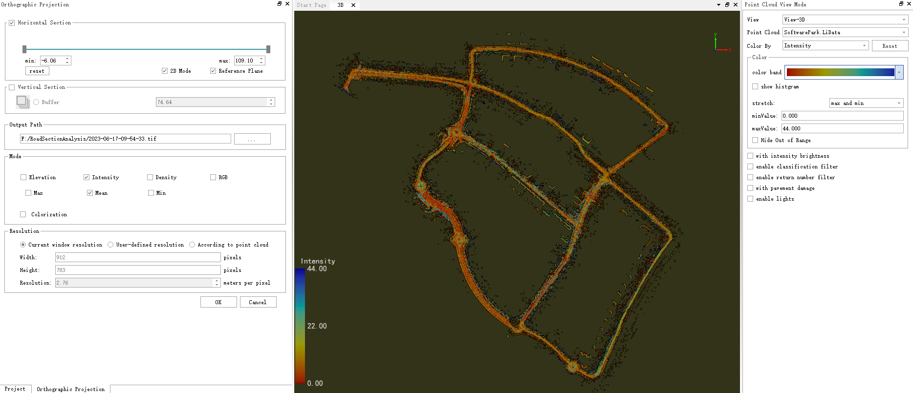
Display by Intensity
- After configuring the point cloud display, choose whether to colorize the exported image. If colorize is not checked, a binary image will be output, as shown:

Export Binary Image by Intensity
- If colorize is checked, a colorized image will be output, as shown:

Export Colorized Image by Intensity
Export by Point Cloud Density
- Check Density in the mode settings of the orthophoto settings window. Since the point cloud display mode does not have a density display option, the 3D window will not show any changes. The color bar for density-based image export is configured in the orthophoto settings window. If colorize is not checked, a binary image will be output, as shown:

Export Binary Image by Density
- If colorize is checked, a colorized image will be output, as shown:

Export Colorized Image by Density
Export by Point Cloud RGB
- Check RGB in the mode settings of the orthophoto settings window. If the point cloud contains RGB information, it will be displayed by RGB in the 3D window; if not, a warning will be shown in the output window. Once RGB is checked, the colorize option becomes ineffective — only colorized images containing the point cloud's RGB information can be exported, as shown:

Display by RGB

Export Colorized Image by RGB
Note: Maximum, Minimum, and Average Options
These settings apply to elevation and intensity exports:
- Maximum: When calculating the pixel value for each image pixel, the maximum value of all point cloud elevations or intensities mapped to that pixel is used.
- Minimum: When calculating the pixel value for each image pixel, the minimum value of all point cloud elevations or intensities mapped to that pixel is used.
- Average: When calculating the pixel value for each image pixel, the average value of all point cloud elevations or intensities mapped to that pixel is used.
RGB Orthophoto Export Logic:
Instead of applying a simple maximum/minimum/average across all points, points are sorted by elevation (top view) or distance from the viewpoint (profile view), and the real color of the point at the corresponding position is taken. This prevents the image from "seeing through" to internal point clouds.
- Supports selecting point colors by "minimum / middle / maximum elevation" in top view, and by "nearest / middle / farthest from viewpoint" in profile view.
- Top view: Min = lowest elevation point, Max = highest elevation point
- Profile view: Min = nearest point to viewpoint, Max = farthest point from viewpoint
Resolution Settings
The export image resolution settings offer three options:
- Current window resolution: The output image aspect ratio and resolution will exactly match the 3D window display. The resolution updates in real time when the point cloud zoom level changes in the 3D window.
- User-defined resolution: The output image aspect ratio will match the 3D window, but the resolution supports custom width and height settings.
- Based on point cloud: The output aspect ratio is calculated from the bounding box of all current point clouds. The image resolution supports user-defined settings.
Hole Filling
Fills "holes" (empty areas) in the exported orthophoto.