Define Projection
Steps
- Click
 Define Projection to open the Define Projection dialog box.
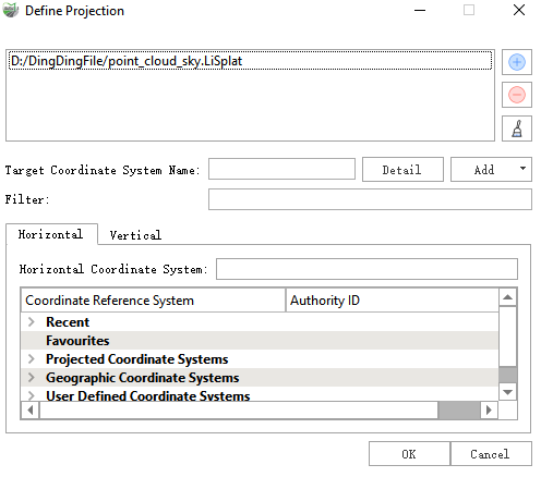
Add one or more Gaussian model files for which a projection needs to be defined, and select the files to process under Splat Files.
Select the target coordinate system from the coordinate reference system list. Enter a coordinate system name, keyword, or EPSG code in Filter to quickly find the required coordinate system.
If necessary, switch between the Horizontal and Vertical tabs to set the horizontal and vertical coordinate systems separately.
Confirm that the correct coordinate reference system is displayed in Target Coordinate System Name, and then click OK to write the coordinate reference system information to the selected Gaussian model files. Click Cancel to close the dialog box without applying the settings.
Parameters
- Splat Files: Controls the selection state of the Gaussian splat files in the file list.
- File List: Displays the Gaussian model files to process. One or more files can be selected for batch processing.
- Add File +: Adds Gaussian model files to the file list.
- Remove -: Removes the selected files from the file list.
- Clear: Clears all data from the file list.
- Target Coordinate System Name: Displays the name of the currently selected coordinate reference system.
- Detail: Displays detailed definition information for the current target coordinate system.
- Add Coordinate System (Add): Adds or customizes a coordinate system through the drop-down menu.
- Filter: Filters coordinate systems by coordinate system name, keyword, or EPSG code.
- Horizontal: Sets the horizontal coordinate system. You can select from recently used, favorite, projected, geographic, and user-defined coordinate systems.
- Vertical: Sets the vertical coordinate system. If it is not set separately, the default elevation definition associated with the selected horizontal coordinate system is used.
- Horizontal Coordinate System: Displays the currently selected horizontal coordinate system.
- Coordinate Reference System: Displays the names and categories of the available coordinate reference systems.
- Authority ID: Displays the authority identifier of a coordinate reference system, such as its EPSG code.
The coordinate reference system list contains the following categories:
- Recent: Recently used coordinate systems.
- Favourites: Favorite coordinate systems.
- Projected Coordinate Systems: Projected coordinate systems.
- Geographic Coordinate Systems: Geographic coordinate systems.
- User Defined Coordinate Systems: User-defined coordinate systems.
Note: Define Projection only writes or updates the coordinate reference system information of a Gaussian model. It does not transform the model coordinates. To change the actual model coordinates, use Transform.