Construction Progress Analysis
Functional Overview
Calculate the newly constructed and demolished parts between two sets of point cloud data, and output the result as point cloud files and HTML reports. In the imagery, red represents an increase, green represents a decrease, and other parts are displayed in grayscale based on elevation values. The changed parts between two sets of point clouds will be output as a point cloud file, and whether the points have changed will be added as an additional attribute to the corresponding LiData file. The newly added part relative to the reference point cloud will be labeled as 1 in the additional attribute, and the reduced part relative to the reference point cloud will be labeled as -1. This function is mainly used for analyzing construction progress.
Usage
Click Terrain > Multi-period Analysis > Construction Progress Analysis.
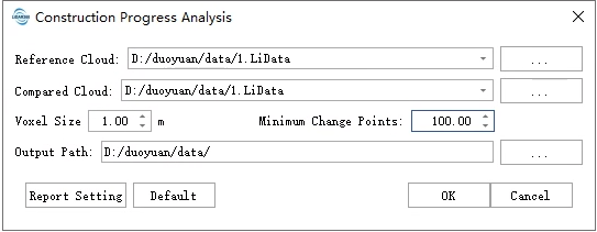
Parameters Settings
- Reference Point Cloud: Select the reference point cloud. The reference point cloud serves as the baseline for comparison, and the reduced portion relative to the compared point cloud will be written as an additional attribute "ConstructionProgressAnalysis" into the reference point cloud, displayed in green in the image.
- Compared Point Cloud: Select the compared point cloud. The increased portion of the compared point cloud relative to the reference point cloud will be written as an additional attribute "ConstructionProgressAnalysis" in the compared point cloud and displayed in red in the image.
- Voxel Size: This is the voxel edge length used to voxelize the point cloud. A smaller value increases detection sensitivity to point cloud changes, while a larger value provides greater coverage but reduced sensitivity.
- Minimum Cluster Size: This specifies the minimum number of points a cluster in the changing point cloud must contain. Clusters with fewer points than this threshold will be considered as noise and not be processed further.
- Default: Click this button to reset all parameters to their default values.
- Output Path: This is the output path for intermediate results and HTML reports.
Note: Both the reference and compared LiDAR data versions must be 2.0 or higher. Lower versions of LiDAR data can be converted to higher versions using Convert Point Cloud to LiData. Note: Additional attribute values can be displayed by right-clicking the data and selecting "Display by Attribute."