Channel Network
This tool extracts river networks from gridded digital elevation data. Initialization options are used to determine where channels begin.
Usage
Click Terrain > Hydrologic Analysis > Channel Network.
Parameter Settings
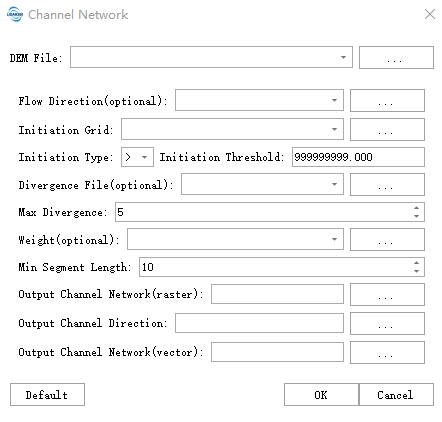
- DEM File: Select the path to the DEM file for analysis. Supports TIFF, TIF, IMG, and DAT formats. Should be a single-band file, typically using filled elevation data. For filling depressions, refer to Fill Depressions.
- Flow Direction (Optional): Flow direction file providing information about flow directions. Values between 1-8 force flow assignment to adjacent cells (1→NE, 2→E, 3→SE, 4→S, 5→SW, 6→W, 7→NW, 8→N). For other values, the algorithm will use its own routing scheme. This option is particularly useful for guiding flow through closed depressions. If empty, the algorithm will calculate flow direction using the D8 method.
- Initiation Grid: Used with "Initiation Type" and "Initiation Threshold" parameters to determine where channels are initialized. Can be flow accumulation data, or alternative inputs like soil permeability or vegetation indices to control channel generation locations.
- Initiation Type: Select less than, equal to, or greater than the initiation threshold to control channel initiation conditions. Default value is "Greater than".
- Initiation Threshold: Channel network initiation threshold - a core parameter. Used with "Initiation Type" and "Initiation Grid" to determine channel initialization conditions. Default value: 999,999,999. Higher values produce sparser networks (main channels only); lower values produce denser networks (including tributaries).
- Divergence File (Optional): Allows channel bifurcation when upstream flow accumulation exceeds downstream cell values. Can simulate real分流 phenomena (value=0 disables bifurcation).
- Maximum Divergence: Limits the maximum number of channels that can diverge from a single cell (requires Divergence ≥1, default: 5). Prevents excessive branching that could chaotic channel networks.
- Weight (Optional): Input raster (e.g., rainfall, soil erosion coefficient) to weight flow accumulation values. Channels may form earlier in wet areas/high erosion areas (even with smaller actual catchment areas).
- Minimum Segment Length: Minimum channel segment length. Isolated segments shorter than this value will be deleted (units: meters). Default: 10. Used to filter noise and improve network continuity.
- Output Channel Network (Raster): If a cell is part of a channel, its pixel value equals the stream order. Otherwise, the cell is marked as NoData.
- Output Channel Direction: If a cell is part of a channel, its value indicates the flow direction (1→NE, 2→E, 3→SE, 4→S, 5→SW, 6→W, 7→NW, 8→N). Otherwise, the pixel is marked as NoData.
- Output Channel Network (Vector): Generated channel network in SHP vector format (lines).
References
@inproceedings{
    author={Schenk, S. K., J. O. Domingue},
    title={Extracting Topographic Structure from Digital Elevation Data for Geographic Information System Analysis},
    booktitle={Photogrammetric Engineering and Remote Sensing},
    year={1988},
}

@inproceedings{
    author={Tarboton, D. G., R. L. Bras, I. Rodríguez-Iturbe},
    title={On the Extraction of Channel Networks from Digital Elevation Data},
    booktitle={Hydrological Processes},
    year={1991},
}