View Azimuth snd Distance
Function Overview
Calculates and displays the azimuth and distance of individual trees relative to a reference point, and saves the computation results.
Usage
Click ALS Forest > View Azimuth and Distance or TLS Forest > View Azimuth and Distance。
A file selection interface will pop up. Select the individual tree attribute file for the point cloud on which to perform the calculation. For the individual tree attribute file format, please refer to the Individual Tree Segmentation Result File Format;
The software will display the individual tree positions on a 2D canvas and show the azimuth and distance attribute calculation settings interface as shown in the figure below.
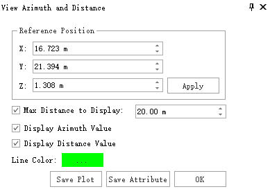
Parameter Settings
- Reference Position:Sets the reference point location. The azimuth and distance attributes for all individual trees are calculated relative to this point. Click "Apply" to update the reference point position settings.
- Max Distance to Display: If unchecked, distance lines connecting all individual trees to the reference point are displayed on the 2D canvas. If checked, only distance lines for trees within the specified maximum distance from the reference point are displayed.
- Display Azimuth Value: If unchecked, the azimuth values between individual trees and the reference point are not displayed on the 2D canvas. If checked, they are displayed.
- Display Distance Value:If unchecked, the distance values between individual trees and the reference point are not displayed on the 2D canvas. If checked, they are displayed.
- Line Color:Sets the drawing color for the distance lines connecting individual trees to the reference point.
- Save Plot:Saves the current drawing on the 2D canvas to a local image file.
- Save Attributes:Saves the calculated azimuth and distance values to the individual tree attribute file.