Attach to Raster
Overview
By extracting the image pixel values, Z values are added to the nodes of various vector feature types (points, lines, and surfaces). The tool does not modify vector feature properties.
Usage
Click Data Management > Vector Tools > Attach to Raster
Settings
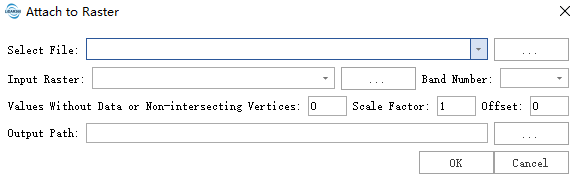
- Select File::Enter the vector file from which you need to remove the duplicate vertices. The input file format supports shp and gpkg formats, and the feature types can be points, lines, and surfaces. For gpkg format, the duplicate point operation is performed on all features of each layer in the file.
- Input Raster:Raster image, extract the pixel values of the vector feature nodes from the image, and use the nearest interpolation.
- Band Number:The band number of the image where the cell value needs to be extracted is the first band by default.
- Values Without Data or Non-intersecting Vertices:If there is no image or the cell is NoData, set the fixed value to the Z value of the vector feature node.
- Scale Factor:The cell value is multiplied by that scaling factor.
Offset:The cell value is applied with a scaling factor and the offset is added as the Z value of the vector feature node.
Output path: The output file path, the output file format is gpkg, if the input is gpkg format, the name of each layer of the output file is the same as the name of each layer in the input, if the input is shp format, the output layer name is 0.