Spatial Structure Quantification
Function Overview
Quantifies the three-dimensional spatial structure of vegetation within the target area of each point cloud dataset. The 3D point cloud structure is divided into grids at specified intervals. The quality of the vegetation spatial configuration is then characterized based on the area ratio or point ratio within each horizontal cross-section.
Usage
Click TLS Forest > Spatial Structure Quantification
Parameter Settings
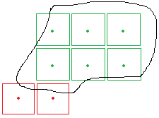
- Region of Interest (Optional):After specifying a region of interest, grids outside this area will not be included in the output. For TIFF results, grids outside the region will be assigned a NODATA value (null). As shown in the figure below, if the black line represents the region of interest, red grids will be assigned NODATA because their centers fall outside the region. Green grids, whose centers are within the region, will be retained. The boundaries of all green grids will be output as a vector file in the results.
- Input Data: Ensure each input point cloud dataset is normalized. The input can be a single point cloud data file or a point cloud dataset; the data to be processed must be opened in LiDAR360 software.
- From Class:Select which classes of points will participate in the calculation.
- XSize(m)(Default: "5"):The grid size for division along the X-direction.
- YSize(m)(Default: "5"):The grid size for division along the Y-direction.
- Vertical Step(m)(Default: "0.2"):The grid size used to divide the point cloud within each statistical unit into 3D grids.
- Method:
- Area(Default: "Average"):Calculates the vegetation area ratio within each vertical cross-section. Assigns a value between 0 and 1 to each cross-section based on this ratio (e.g., 0%, 0-20%, 20-40%, 40-60%, 60-80%, 80-100% correspond to values of 0, 0.2, 0.4, 0.6, 0.8, 1). The final result is either the sum or the average of all these assigned values.
- Point Count:Assigns values based on the ratio of vegetation points within each vertical cross-section.
- Output Path:The results can be output as TIFF files or a CSV file. After processing, each input point cloud data file will generate multiple corresponding TIFF files or a single CSV file.