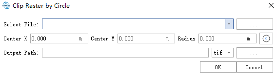
Clip Raster by Circle
Summary
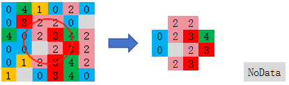
Clip raster images using a circle. There are two ways to define the circle: by specifying the center coordinates and radius, or by drawing the circle with the mouse in the viewer. If the input raster has NoData, pixels outside the polygon in the output raster will be filled with the same NoData value; if the input raster does not have NoData, pixels outside the polygon will be filled with a value of 0. The input raster should have a spatial reference system.
Usage
ClickData Management> Raster Tools > Clip Raster by Circle
Settings
- Select File::Select raster file. Common formats such as tif, tiff, dat, and img are supported.
- Center X:X coordinate of the circle center. The unit is the same as the platform unit, and no unit conversion is performed.
- Center Y:Y coordinate of the circle center. The unit is the same as the platform unit, and no unit conversion is performed.
Radius:Radius of the circle. The unit is the same as the platform unit, and no unit conversion is performed.
Output Path: Output Path: The result output folder path. After execution, the clipped raster will be output, supporting tif, tiff, and img formats.