Automatic Registration of Forest
Function Overview
Automatic Registration of Forest automatically registers and fuses forestry point cloud data collected from different platforms, such as airborne, terrestrial, and handheld platforms, to compensate for the limitations of a single data source. ICP optimization is recommended only when the initial result is insufficient. Ground points are recommended for optimization to improve accuracy.
Usage
Click ALS Forest > Registration > Automatic Registration of Forest.
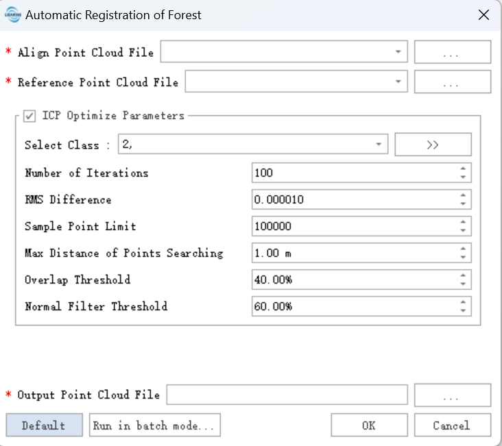
Parameter Settings
Reference Point Cloud File: Reference point cloud data. After registration, the registration point cloud is transformed into the coordinate system of the reference point cloud.
Registration Point Cloud File: Point cloud to be registered. After registration, the rotation and translation matrix is applied to this point cloud, and a new registered file is generated.
ICP Optimization (optional):
Select Class: Point class used for optimization. Ground points are used by default. If the result is not satisfactory without optimization, try optimizing with ground points.
Registration Type: Point-to-point and point-to-plane registration are supported. Point-to-point estimates transformation parameters by minimizing the Euclidean distance between matched points. Point-to-plane minimizes the normal-plane distance between source and target points. When the point cloud contains ground, walls, or other planar objects, point-to-plane registration is preferred.
Sampling Point Limit: Used for downsampling the original data. The algorithm randomly samples the original point cloud to the specified number of points and uses the subset for registration.
Maximum Point Search Distance (default: 1 m): Used to build matching pairs in nearest-neighbor search. If coarse registration accuracy is low, for example when two walls are more than 5 m apart after coarse registration, a 1 m search distance may fail to associate the wall features. In this case, increase the search distance, for example to 10 m, run one global optimization to pull the point clouds closer, and then set the search distance back to 1 m for another optimization. Usually 2 to 3 optimizations can produce a good registration result.
Overlap Threshold (default: 40%): Used to determine which stations are included in adjustment matching during inter-station nearest-neighbor search. This parameter works together with the maximum inter-station search distance. When the distance between two stations is less than the maximum search distance, the overlap rate is checked. If it is greater than the threshold, the two stations are included in the adjustment network.
Normal Filtering Threshold (default: 60%): Used to filter extracted line and plane features. The algorithm keeps this percentage of features for calculation. A larger value uses more features and may improve the optimization result, but takes longer. A value greater than 50% is recommended.