Agricultural Stress Vegetation Analysis
Function Overview
Using Agricultural Stress Vegetation Tool to create a spatial distribution map of regional vegetation flammability. This distribution map can be used for forest planning and also for analyzing fire risks in mixed urban-suburban areas.The Agricultural Stress Tool divides the input scene into nine classes(1-9), from lowest stress to highest stress.
Usage
Click Spectrum > Agricultural Stress Vegetation Analysis.
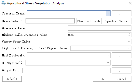
Click the Spectrum Subset button to select the band of the hyperspectral image.

Parameter Setting
- Input hyperspectral image data: Input the hyperspectral image data file. Data should be pre-processed, such as radiation calibration and atmospheric correction.
- Band selection: Select the band of the hyperspectral image. For PCA function, please click Clear the bad band before using it.
- Greenness index: Select greenness index. Currently only NDVI is supported.
- Minimum valid greenness value: Range 0-1. Any pixels in the image with values below this threshold will be masked in the classification results. Default is 0.
- Canopy water index: Select canopy water index. Currently only WBI and NDWI are supported.
- Light use efficiency or leaf pigment index: Select light use efficiency or leaf pigment index. Currently only ARI1, CRI1, PRI, and SIPI are supported.
- ROI: Only the minimum external rectangle in the ROI area is calculated after selection.
- Mask: Only the effective area of the mask is calculated after selection.
- Output path: The generated tif path.