Select Tool
Select tool supports to choose arbitrarily in the main window, TIN window, and profile window. After selecting the area, it will be classified by the selected method in the classify panel.
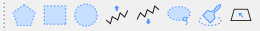
| Icon | Description | Hot Key |
|---|---|---|
| Polygon Select | Shift+P | |
| Rectangle Select | Shift+R | |
| Circle Select | Shift+C | |
| Above the Polyline Select | L | |
| Below the Polyline Select | Shift+L | |
| Lasso Select | Ctrl+Shift+L | |
| Circular Brush Select | Shift+F | |
| Detect Plane | Ctrl+Shift+D | |
| Switch Selecting Tool | Shift+Q |
Circular Brush
- Selection Radius: By setting the radius in pixel of the circular brush, control the size of selecting area.
Detect Plane
Detect plane tool performs the plane growth algorithm by fitting a plane with the points in a selected circle to detect the points within the same plane.
- Tolerance (meter): The threshold of the distance from the point to be detected to the fitting plane in the selected area. This threshold is aimed to control the thickness of the detected plane.
- Range (pixel): The range of the points used to generate the initial fitting plane. Users should control the range to ensure that the points are in the same plane.
- Step Length: The step length of the outward extension of the plane detection.
Detect Region by SAM
Load the matched image and point cloud data in the scene. After enabling the function, a feature file will be generated in the same directory as the image. Through mouse interaction on the image data, an area can be detected. Once confirmed, the point cloud within the area will be converted from the initial category to the target category. Classification operations are performed in the following two cases:
- When neither the Shift nor Alt key is pressed, clicking the mouse in the scene will classify the last detected polygon area.
- Clicking the Confirm button on the interface will classify the polygon area displayed in the scene.
Parameter Settings
Selection Tool: Specifies the interaction mode for automatically extracting vectors.
- Point: Left-click the mouse to automatically extract vectors. Hold the Shift key while clicking to add positive points, or hold the Alt key while clicking to add negative points.
- Rectangle: Left-click the mouse to set the start point of the rectangle, move the mouse and left-click to set the end point of the rectangle, automatically extracting the vector.
- Confirm: Confirms the current area, and the polygon area displayed in the scene will be classified. After this, positive or negative points can no longer be added until the next click and area detection.
Simplify: Simplifies the extracted vector.
- Maximum Distance: Specifies the maximum distance deviation from a point to the line. As the distance decreases, more points are retained and fewer points are deleted from the line.
Smooth Method: Smoothes the extracted vector.
- Mean Smoothing (3\5\7 Neighborhoods): Applies mean smoothing to each point on the vector line using a 3\5\7 neighborhood.
- Bezier (Line Control): Uses a piecewise Bezier curve for smoothing, and the resulting vector line does not pass through the control points.
- Bezier (Point Control): Uses a piecewise Bezier curve for smoothing, and the resulting vector line passes through the control points.
- B-Spline (Point Control): Uses a cubic B-spline curve for smoothing, and the resulting vector line passes through some control points.
- B-Spline Fit: Uses a cubic B-spline curve for fitting, and the resulting vector line does not pass through the control points.
Regularization: Normalizes the automatically extracted vector.
- Angle Tolerance: Line segments with an angle smaller than this threshold will be merged into a straight line.
- Maximum Distance: Specifies the maximum distance deviation from a point to the line. As the distance decreases, more points are retained and fewer points are deleted from the line.
Smart Classification
After the point cloud is tiled, semi-automated tools can be used for classification. Once the function is activated, click the tiled point cloud data in the scene with the mouse. Seed points will first be selected based on the point cloud around the mouse click, and automatic classification will then be performed according to the parameter settings.
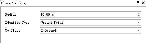
Parameter Settings:
- Radius: Points within this radius centered on the seed point will undergo automatic classification.
- Identify Type: The category of point cloud to be identified.
- To Class: The target category for classifying the identified points.