Convert Point Cloud to LAS
Summary
Convert Point Cloud to LAS can convert point clouds in LiData format to LAS format, namely the standard Lidar point cloud data format.
Usage
Click Data Management > Conversion > Convert Point Cloud to LAS
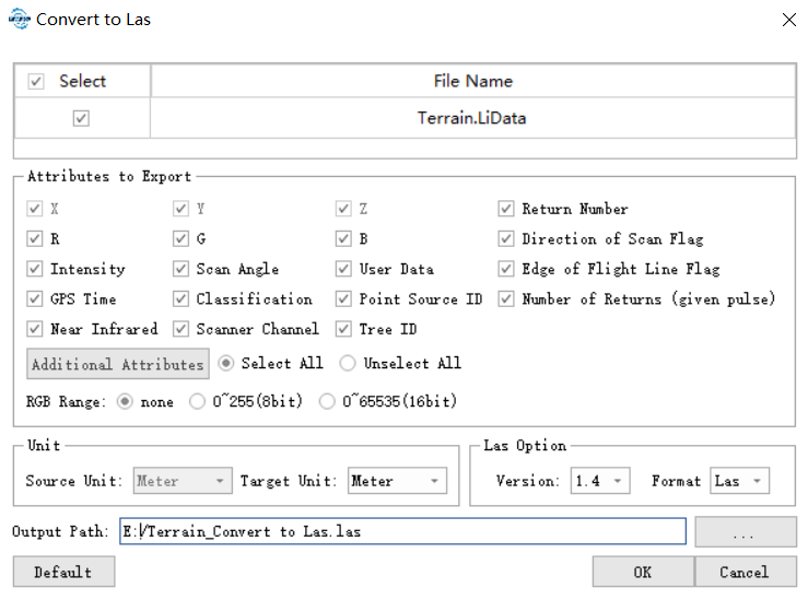
Settings
- Select Input File: The input file can be a single point cloud data file or multiple data files. File Format: *.LiData.
- Attributes to Export: Users can select the attributes that need to be exported. All Las attributes are supported.
- RGB Range: There are three options for the RGB range.
- none:Output according to the original RGB range of the selected file.
- 0~255 (8 bits): Output with the RGB mapped to 0~255. If the color range of the file selected is 0~1 or 0~65535, it can be mapped to 0~255 for output.
- 0~65535 (16 bits):Output with the RGB mapped to 0~65535. If the color range of the file selected is 0~1 or 0~255, it can be mapped to 0~65535 for output.
- Source Unit: The unit of the LiData to be exported as LAS file. As the only supported unit in LiDAR360 is meters currently, this option is fixed as "meter".
- Target Unit: The unit of the exporting LAS file. Choose from meters, decimeters, centimeters, millimeters, feet, and inches.
- LAS Version (Default value is 1.5): The version of the exporting LAS file. Choose from 1.2 to 1.5. Please refer to LiData Format for details. When exporting from a higher version to a lower version, the exceeded field range limitation will be set as 0.
- Output Path: Path of the output folder. After the conversion being executed, the converted new file(s) will be generated.