Simulate Terrain Point
Functional Overview
The terrain point simulation tool mainly solves the phenomenon of missing terrain points in mountainous areas caused by dense vegetation occlusion, and simulates the real mountainous terrain triangular mesh by predicting the terrain of the missing points.
Usage
The terrain point estimation function belongs to the profile editing module. Activate the profile editing module -> click "Start Editing" -> execute "TIN" to generate this function. Click the terrain point estimation, and the parameter dialog box will pop up; select the profile tool, draw the profile of the simulated terrain point area, select the measurement tool in the profile window, and measure the height of the occluded vegetation; set the parameters in the parameter dialog box, click the select button (left mouse button Add a point, right-click to go back, double-click OK) to select the simulation area.
Parameters settings
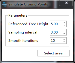
By Reference trees: simulate based on the highest point of the covered terrain
Referenced Tree Height: approximate height of obstructing vegetation measured by profile;
Sampling Interval: average distance between simulated points;
Smooth Iterations: number of iterations for smoothing simulated ground points, larger values result in smoother simulation areas;
By Neighbor Ground Points: simulate based on neighboring ground points within the area to be simulated, selection range should cover neighboring areas
Sampling Interval: average distance between simulated points;
Smooth Iterations: number of iterations for smoothing simulated ground points, larger values result in smoother simulation areas.
Delete Simulated Points
Deletes the specified set of simulated terrain points in the scene.
Usage
Click the "Select" button in the toolbar to enable the selection function, select the simulated terrain point set in the scene, and click "Delete" in the toolbar  button deletes the point set.