Calculate LAI by Polygon
Summary
Calculate the Leaf Area Index of the point cloud data in the given Polygon.
Usage
Click ALS Forest > Forestry Metrics > Calculate LAI by Polygon to calculate the leaf area index in the given area.
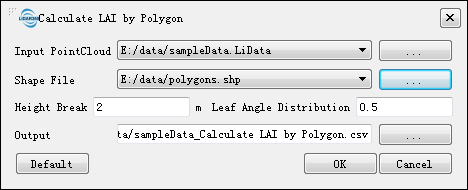
Settings
Input Data: Please make sure that all the input data is normalized. The data to be processed can be opened in LiDAR360, or added by users.
Vector File: The vector file contains the polygon(s) in which the leaf area index need to calculated. The vector data to be processed can be opened in LiDAR360, or add by users.
Height Threshold (meters) (default value is "2"): The threshold used to distinguish the ground points and the trees. The points lower than the given height will be not be considered as vegetation points. The default value is 2 meters.
Leaf Inclination Distribution (default value is "0.5"): A mathematical expression of leaf probability distribution in three-dimensional space. It is related to vegetation type, leaf inclination and beam direction. Users can determine the value of the leaf inclination distribution according to the empirical formula and the actual situation of the forest. Previous studies have shown that the elliptical distribution of leaf inclination may be applicable to the actual situation in most forests, with a value of 0.5.
Output Path: Output path of the result CSV file.
Note: Only when the point cloud data is loaded in the software can you use the Intensity Metrics function; otherwise, the message "There is no point cloud data meeting the conditions of calculation!" will pop up. If the maximum Z value of the point cloud is greater than 200 m or the maximum Z minus the minimum Z is greater than 200 m, the data is not considered to have been normalized, and the prompt information shown in the figure below will pop up. Click “YES” to keep using this type of data in the operation; otherwise, click "NO" and reselect the input data file.