Calculate Elevation Metrics by Polygon
Summary
Calculate the Elevation Metrics of the point cloud data in the given Polygon.
Usage
Click ALS Forestry > Forestry Metrics > Calculate Elevation Metrics by Polygon to calculate the height metrics in the given area.
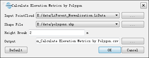
Settings
Input Data: Please make sure that all the input data is normalized. The data to be processed can be opened in LiDAR360, or add by users.
Vector File: The vector file contains the polygon(s) in which the elevation metrics need to calculated. The vector data to be processed can be opened in LiDAR360, or added by users.
Output Path: Output path of the result CSV file.