Individual Tree Attributes Statistics
Description
This function is mainly used to perform attribute statistics and attribute expansion on point clouds that have already been normalized and segmented into individual trees, generating individual tree attribute files. It can create new files or update existing ones.
Usage
Click TLS Forest > Tree Attributes > Individual Tree Attributes Statistics.
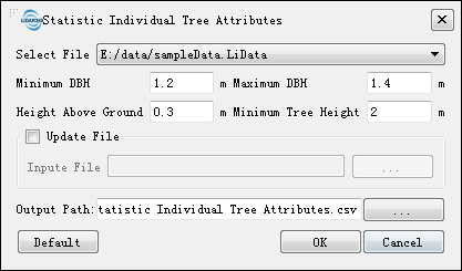

Parameters
The parameters are divided into two pages. The first page allows you to select the target file and the attributes to be calculated, and the second page allows you to set specific statistical parameters.
First Page
- New File: Generates a new individual tree attribute file. For the specific file format, refer to Individual Tree Segmentation Result File Format.
- Update File: Updates an existing individual tree attribute file, mutually exclusive with "New File". If the attribute file does not contain the selected attributes, they will be added.
- Attribute Selection: At least one individual tree attribute needs to be selected for statistics. The supported attributes include location, tree height, DBH, ground diameter, crown diameter, north-south crown diameter, east-west crown diameter, crown area, crown volume, clear height, elevation, tree species, slope, crown height, height-diameter ratio, crown-height ratio, stem form, crown offset, crown contour, stem tilt, stem curvature percentage, stem segments, stem volume, azimuth, and distance. Some calculations are affected by Forestry Configuration.
- Forestry Configuration: Opens Forestry Configuration to control additional attribute calculation settings.
Second Page
- Input Point Cloud: Select the point cloud to be analyzed. The point cloud must have been normalized and segmented into individual trees.
- Select ROI: Import a vector file as an ROI mask. The vector file must contain one or more polygons. Trees whose locations fall inside any polygon are kept; the others are discarded.
- Height Above Ground (meters) (default is "0.3"): Only point clouds above this height will be analyzed.
- Minimum Tree Height: Only individual trees taller than this value will be analyzed.
- Stem Class: Select the stem class for accurate stem volume, curvature, and related calculations.
- Curvature and Trunk Volume: This option is displayed only when stem curvature, cutting analysis, or stem volume is selected. Refer to Trunk Curvature Calculation for parameters.
- Tree Species: Uses deep learning or LLM-based methods to obtain tree species. The supported data sources are point cloud, panoramic images, and LLM.
- Point Cloud: Identifies tree species directly from point clouds.
- Tree Species Confidence: The extracted tree species confidence must be higher than this value; otherwise, the result is discarded.
- Prefer GPU (selected by default): Prefer GPU for tree species extraction.
- Select Model: Select the training model to use. The software provides a default model, and custom tree species models can also be selected after they are created.
- Panoramic Images:
- Tree Species Confidence: The extracted tree species confidence must be higher than this value; otherwise, the result is discarded.
- Panorama List File: Import the panorama list file
imglist. - Use LLM Optimization: When no tree species is identified in panoramic mode, use the LLM as a supplementary method.
- LLM: Identifies tree species directly from the LLM and the calculated individual tree attributes. Panorama images and a projected coordinate system can be provided optionally to improve identification accuracy.
- Point Cloud: Identifies tree species directly from point clouds.
- Reference Point File: The reference point file is a comma-separated text file with two rows, containing three fields: X, Y, and Radius. X and Y are the coordinates of the reference point, and Radius is the radius. If a reference point file is provided, the azimuth and distance of trees within the radius centered on the reference point will be calculated and added as extended attributes to the individual tree attribute file.
- Slope File: This option appears when "Slope" is selected. The slope file is in TIFF format. If a slope file is provided, the slope at the tree location will be extracted from the file and added as an extended attribute to the individual tree attribute file.
- DEM File: This option appears when "Elevation" is selected. The DEM file is in TIFF format. If a DEM file is provided, the ground height at the tree location will be extracted from the file and added as an extended attribute to the individual tree attribute file.
Below is an example of a reference point file:
X,Y,Radius
322716.24,4102494.69,15.0
Below is an example of an individual tree attribute file:
TreeID, TreeLocationX, TreeLocationY
1, 322716.24, 4102494.69
2, 322751.21, 4102499.9
3, 322519.35, 4102499.3
Below is an example of an individual tree attribute file after importing the "Reference Point File" and performing statistics (in CSV format):
TreeID, TreeLocationX, TreeLocationY, Azimuth, Distance
1, 322716.24, 4102494.69, 36.165, 8.982
2, 322751.21, 4102499.9, 41.282, 4.491
3, 322519.35, 4102499.3, 32.008, 4.708