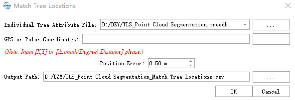
Match Tree Locations
Function Overview
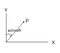
The Match Tree Locations function enables the registration of tree locations from an Individual Tree Attribute File with tree positions in other coordinate systems on the XY plane. The number of coordinates does not need to be exactly matched. The other coordinate system can be a GPS projected coordinate system, a custom Cartesian coordinate system, or even a polar coordinate system. For Cartesian coordinates, X and Y values are required; for polar coordinates, azimuth (in degrees) and distance are needed. The definition of azimuth is illustrated in the figure below. For the Individual Tree Attribute File format, please refer to the TLS Individual Tree Segmentation Result File Format in the appendix.
Usage
Click TLS Forest > Match Tree Locations
Parameter Settings
- Individual Tree Attribute File:For the specific file format, please refer to the TLS Individual Tree Segmentation Result File Format.
- GPS or Polar Coordinates:For Cartesian coordinates, input X and Y values. For polar coordinates, input azimuth (in degrees) and distance. Only one type can be used; if both are provided, GPS points will be prioritized.
- Positional Error: The relative offset error between the GPS points and the actual tree positions. A smaller value yields higher registration accuracy but may result in failure to find matching pairs; an excessively large value increases the probability of incorrect matches.
- Output Path:The output is a CSV file that adds all individual tree attributes corresponding to each registered coordinate row from the original CSV file, along with the registration positional error.