Extract Roads by Deep Learning
Function Overview
Select 3-channel or single-channel imagery, use a deep learning model to extract road polygons, and generate road line vector files along with corresponding road mask images. The mask image contains two classification values: classification value 0 represents unclassified areas, and classification value 1 represents roads.
Usage
Click Classification > Extract Roads by Deep Learning
Parameter Settings
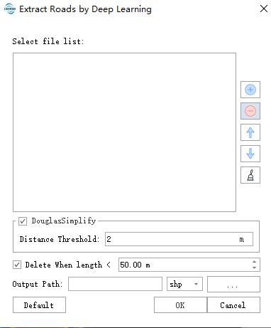
- Douglas Simplify: Check to simplify the road contours.
- Distance Threshold: The larger this value, the more significant the simplification effect.
- Delete when length Less Than: Delete road contour lines shorter than the specified value to filter out incorrectly identified roads.
- Output Path: Set the output path and format for the resulting vector file.
Input
High-resolution imagery (10-25 cm) with 8-bit depth and at least three bands.
Model Architecture
The model is built on the PP-LiteSeg architecture from the PaddleSeg package.
Accuracy Metrics
The model achieves a mean Intersection over Union (mIoU) of 81%.