Subscribe

LiDAR360 Tunnel Modelling Solution: 10 times more efficient and high-quality results!

-- 11 Dec 2023 --

Tunnels are the main working places for underground mining production. The measurement and reconstruction of their structures are of great significance to the safe production and construction planning of underground mines.

For the traditional measurement of tunnel structure, a traverse survey is used to determine the center line, and a detail survey is used to determine the distance from the sighting point to the left and right tunnel walls to generate a tunnel plan. Such results are not intuitive for the elevation position relationships such as slope changes and spatial intersections of the tunnel, which leads to the frequent occurrence of tunnel penetration deviation accidents with elevation deviation as the main reason. Manual 3D modelling has the problem of extremely low efficiency and is difficult to meet the requirements of daily production.


In response to many problems in mining production, various government agencies have issued a number of policies and supports in recent years, requiring the construction of smart mines and improving automation and work efficiency. The industry has also responded - rapid environmental perception + automatic modelling based on LiDAR solution.


Using LiGrip to quickly collect field data + LiDAR360 to automatically build a 3D model has many advantages over traditional methods, such as high accuracy, high efficiency, and inclusion of 3D features.


Taking a 1,000-meter-long tunnel as an example, using the traditional measurement + floor plan method requires 2 to 3 people in the field and 1 person in the office to carry out the operation. One station is laid out every 10 meters. It takes about one day in the field and the results are only displayed with 2D features.


Using LiGrip to collect data requires only one person to start the work, complete the collection in 20 minutes, and complete the data processing in 30 minutes.


The result data can be further improved and analyzed with tools including remove outliers and extract tunnel points with one click in the LiDAR360 software. Automatic modelling can be completed in 15 seconds, and the results can be output in a few minutes!

The overall process is as follows:


02ada3ddcf0bf405e54c471956984a7f.png


Figure 1. The whole process of rapid tunnel modelling
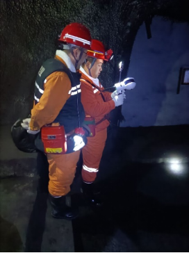

image.png

 
Figure 2. Data collection in the field
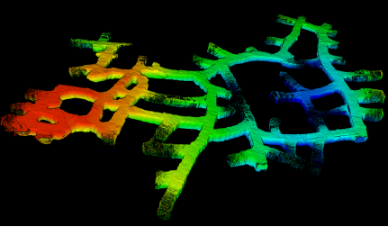

image.png image.png


Figure 3. Data processing results—raw point cloud


image.png


Figure 4. Preprocessing results


Preprocessing includes operations such as removing outliers and extracting tunnel points, which can filter out the noise existing in the tunnel point cloud. As can be seen from Figures 3 and 4, pipes, cables, figures and other debris inside the tunnel have been automatically filtered out, leaving only the tunnel wall point cloud.


image.png image.png


Figure 5. Automatic modeling results


The total length of the tunnel in the measured data is about 1,000 meters, and the one-click automatic modelling in LiDAR360 only takes 15 seconds! The effect is shown in Figure 5. The internal structure of the tunnel is clear and without noise. However, since the tunnel is not a closed structure, the model has a small number of holes at the entrance.


image.png


Figure 6. Semi-automatic reconstruction – one-click hole repair


In addition to automatic modelling, LiDAR360 also provides a variety of processing tools that can edit the shape of the tunnels, and provides a variety of semi-automatic tools, including one-click hole filling, one-click smoothing, one-click simplification, etc., to help users deliver ideal results quickly. As shown in Figure 6, the hole-filling function can instantly fill the holes in the tunnel wall with one click (the video speed is the actual running speed of the software).


image.png image.png


Figure 7. Final results of the model


The sample data is located in a coal mine area in Northern China, with a tunnel length of 1,000 meters. It takes less than 10 minutes to import the raw data into LiDAR360 to output medium to high-quality model results. The entire process of kilometer data collection + modelling is controlled in less than 1 hour. While the results are of high quality, it is 10 times more efficient than traditional methods! The model can assist through analysis, be used for backfilling volume calculation, and can be output to common formats such as obj. It is closely connected with applications such as smart mines and mine digital twins, bringing real value to industry users!


Tunnels are the main working places for underground mining production. The measurement and reconstruction of their structures are of great significance to the safe production and construction planning of underground mines.

For the traditional measurement of tunnel structure, a traverse survey is used to determine the center line, and a detail survey is used to determine the distance from the sighting point to the left and right tunnel walls to generate a tunnel plan. Such results are not intuitive for the elevation position relationships such as slope changes and spatial intersections of the tunnel, which leads to the frequent occurrence of tunnel penetration deviation accidents with elevation deviation as the main reason. Manual 3D modelling has the problem of extremely low efficiency and is difficult to meet the requirements of daily production.


In response to many problems in mining production, various government agencies have issued a number of policies and supports in recent years, requiring the construction of smart mines and improving automation and work efficiency. The industry has also responded - rapid environmental perception + automatic modelling based on LiDAR solution.


Using LiGrip to quickly collect field data + LiDAR360 to automatically build a 3D model has many advantages over traditional methods, such as high accuracy, high efficiency, and inclusion of 3D features.


Taking a 1,000-meter-long tunnel as an example, using the traditional measurement + floor plan method requires 2 to 3 people in the field and 1 person in the office to carry out the operation. One station is laid out every 10 meters. It takes about one day in the field and the results are only displayed with 2D features.


Using LiGrip to collect data requires only one person to start the work, complete the collection in 20 minutes, and complete the data processing in 30 minutes.


The result data can be further improved and analyzed with tools including remove outliers and extract tunnel points with one click in the LiDAR360 software. Automatic modelling can be completed in 15 seconds, and the results can be output in a few minutes!

The overall process is as follows:


02ada3ddcf0bf405e54c471956984a7f.png


Figure 1. The whole process of rapid tunnel modelling


image.png

 
Figure 2. Data collection in the field
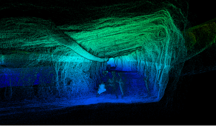

image.png image.png


Figure 3. Data processing results—raw point cloud
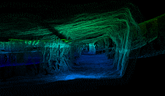

image.png


Figure 4. Preprocessing results


Preprocessing includes operations such as removing outliers and extracting tunnel points, which can filter out the noise existing in the tunnel point cloud. As can be seen from Figures 3 and 4, pipes, cables, figures and other debris inside the tunnel have been automatically filtered out, leaving only the tunnel wall point cloud.
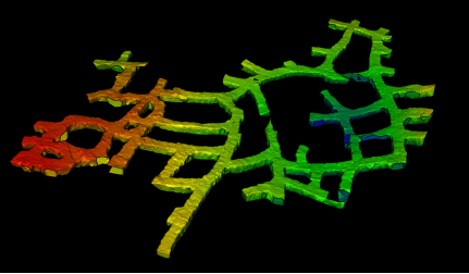
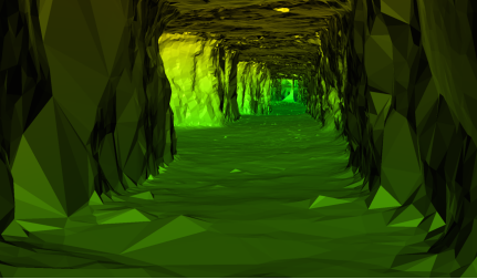
image.png image.png


Figure 5. Automatic modeling results


The total length of the tunnel in the measured data is about 1,000 meters, and the one-click automatic modelling in LiDAR360 only takes 15 seconds! The effect is shown in Figure 5. The internal structure of the tunnel is clear and without noise. However, since the tunnel is not a closed structure, the model has a small number of holes at the entrance.
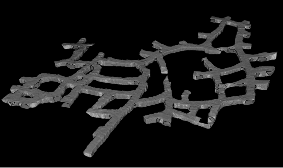

image.png


Figure 6. Semi-automatic reconstruction – one-click hole repair


In addition to automatic modelling, LiDAR360 also provides a variety of processing tools that can edit the shape of the tunnels, and provides a variety of semi-automatic tools, including one-click hole filling, one-click smoothing, one-click simplification, etc., to help users deliver ideal results quickly. As shown in Figure 6, the hole-filling function can instantly fill the holes in the tunnel wall with one click (the video speed is the actual running speed of the software).
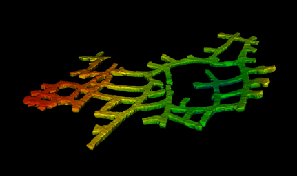
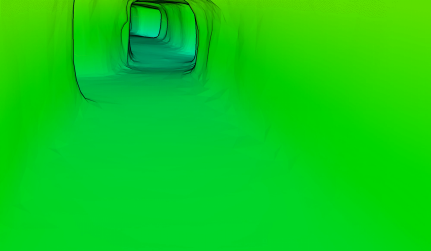
image.png image.png


Figure 7. Final results of the model


The sample data is located in a coal mine area in Northern China, with a tunnel length of 1,000 meters. It takes less than 10 minutes to import the raw data into LiDAR360 to output medium to high-quality model results. The entire process of kilometer data collection + modelling is controlled in less than 1 hour. While the results are of high quality, it is 10 times more efficient than traditional methods! The model can assist through analysis, be used for backfilling volume calculation, and can be output to common formats such as obj. It is closely connected with applications such as smart mines and mine digital twins, bringing real value to industry users!


Recommended Articles

HOW CAN WE HELP YOU?
Message us your questions and contact information.
We’ll get back to you right away!