## Extract Color from Image ##
### Summary ###
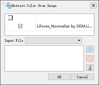
Extract Color from Image tool can extract RGB information from multi-band imagery and assigned them to each point in a point cloud. The user is required to enter one or more multi-band images that overlapping with the extend of the point cloud data.
### Usage ###
Click *Data Management > Point Cloud Tools > Extract Color from Image*
### Settings ###
- **Select File**: Input one or more point cloud data files. File format: *.LiData.
- **Ortho Image/Image Project**: Choose whether to map using multi-band imagery or image projects.
- **Overwrite Color**: Specify whether to overwrite points that already have color value attributes.
- **Input Files**:
- If selecting multi-band imagery, you need to input multi-band imagery data with the same geographic location as the point cloud. If the imagery data is already open in the software, select it from the dropdown menu. Alternatively, click  to open external imagery data. Click
  to remove selected data, and click
  to clear the imagery data list. After processing, the display mode of the point cloud data will automatically switch to RGB display (you can also click the
  button on the toolbar to display the point cloud in RGB). File format: *.tif.
- If selecting image projects, select the image project file (*.liaep) from the dropdown menu. For information on importing image projects, refer to the [Import Data](../../ProjectTools/AddData.md) page for adding aerial triangulation results data.
button on the toolbar to display the point cloud in RGB). File format: *.tif.
- If selecting image projects, select the image project file (*.liaep) from the dropdown menu. For information on importing image projects, refer to the [Import Data](../../ProjectTools/AddData.md) page for adding aerial triangulation results data.