## Extract by Time ##
### Summary ###
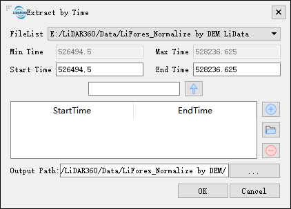
Extract by GPS time tool can extract all the point cloud data within the user-defined GPS time range, and save them in a file.
### Usage ###
Click *Data Management > Extract > Extract by Time*
### Settings ###
- **File List**: Select the file to be processed from the drop-down list.
- **Min Time**: Displays the minimum GPS time value in the point cloud file selected by the user. This value does not require user settings.
- **Max Time**: Displays the maximum GPS time value in the point cloud file selected by the user. This value does not require user settings.
- **Start Time (default value is "min Time")**: Input the minimum GPS time value of the point cloud data to be extracted.
- **End Time (default value is "max Time")**: Input the maximum GPS time value of the point cloud data to be extracted. This value must be larger than the start time.
- ** **: If you want to extract the point cloud at a specified interval, enter the interval value in the text box, and then click this button, the values of the start time and end time will increase at the set interval.
- **
**: If you want to extract the point cloud at a specified interval, enter the interval value in the text box, and then click this button, the values of the start time and end time will increase at the set interval.
- ** **: Add the input time range to the range list. All point cloud data in the time range will be extracted into one file.
- **
**: Add the input time range to the range list. All point cloud data in the time range will be extracted into one file.
- ** **: Users can click this button to load external GPS range file. The time range in the file needs to be between the **min Time** and the **max Time**. The file format can be referred to the appendix for information in the [GPS time extract file format](../../../Appendix/GPSTimeExtractFileFormat.md).
- **
**: Users can click this button to load external GPS range file. The time range in the file needs to be between the **min Time** and the **max Time**. The file format can be referred to the appendix for information in the [GPS time extract file format](../../../Appendix/GPSTimeExtractFileFormat.md).
- ** **: Users select a row in the time range list and click this button to remove the row from the list.
- **Output Path**: Path of the output folder. After the function being executed, the extracted new file will be generated.
**: Users select a row in the time range list and click this button to remove the row from the list.
- **Output Path**: Path of the output folder. After the function being executed, the extracted new file will be generated.