Subscribe

Direct Terrain Following Flight for Aerial Surveys of High Relief Terrain!

-- 21 Mar 2024 --

Aerial Surveying of Highly Undulating Terrain


How to Address Point Cloud Density Variations?

When conducting large-scale aerial survey operations outdoors, we often encounter terrain with large elevation changes. When performing fixed-altitude aerial surveys using lightweight short-range LiDAR systems mounted on unmanned aerial vehicles (UAVs), the effective measurement range is typically less than 300 meters. When the elevation difference is too large, insufficient measurement range will lead to sparse or even missing point cloud density in areas with relatively low elevations. Inconsistencies in overall point cloud resolution and density parameters can affect reconstruction results during data post-processing.

To address this issue, we can consider using a long-range LiDAR system. However, the high price of these systems often prevents many geospatial surveyors from adopting them.


Is there a more cost-effective solution? Yes! We can achieve it by utilizing the terrain-following function during aerial survey operations with UAVs equipped with short-range LiDAR systems. By consistently flying the UAV at a relative height above the ground that corresponds to the terrain variations, we can overcome this issue. This is the terrain-following functionality in aerial surveying.


Currently, there are two commonly used terrain-following methods on the market. The first method is to import digital surface model (DSM) files into flight planning software to generate variable altitude flight paths. DSM files can be downloaded for free from geospatial websites, but they tend to be lower resolution and less timely. Another approach is real-time terrain-following based on image data. However, this method is limited by lighting conditions and the drone lacks the ability to carry additional payloads, resulting in the inability to capture LiDAR point cloud data. Both methods have significant limitations. Is there a more convenient and efficient solution for terrain following?


GVI's Autonomous Terrain-following Function Enables Direct Terrain-following Flight without the Need for DSMs.


In response to the above problems, GreenValley International LiAir X series products incorporate a newly developed autonomous terrain following flight function specially developed for terrain surveying and mapping.


When used with the GreenValley APP and the DJI M300 drone, the system does not need to rely on DSM information specific to the measurement area. Instead, it leverages real-time processing of LiDAR point cloud data to generate local DSMs for terrain assessment. By considering the relative height of the drone to the ground, historical terrain data, and flight trajectory, the flight height is dynamically adjusted in real-time. This enables real-time terrain following flights without relying on pre-existing DSM data.


This feature greatly reduces data preparation time in advance and can be deployed and used immediately.
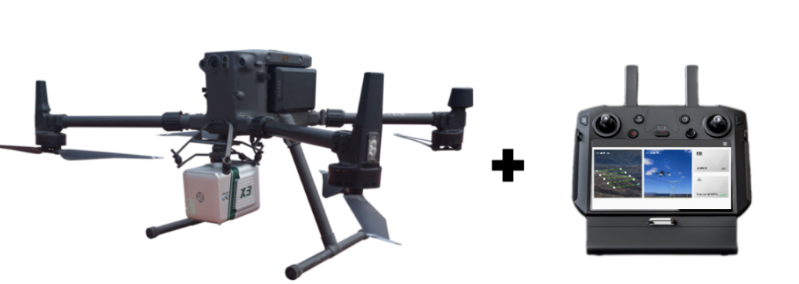


image.png


Process and Core Functionality Overview


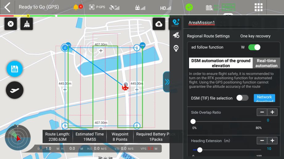
GreenValley App supports both DSM-based terrain following and real-time terrain following modes. Users can choose the appropriate mode according to their specific needs.

图片2.png


When using the DSM-based terrain following mode, the GreenValley App supports two ways to obtain DSM data: local DSM import and online DSM download. The online download option allows users to automatically download the DSM file of the measured area via an internet connection. This eliminates the need for post-processing to generate DSM files or search resources online, saving time and greatly enhancing user-friendliness and operating experience.
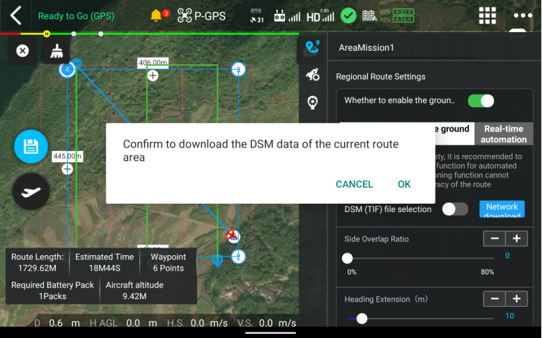


image.png


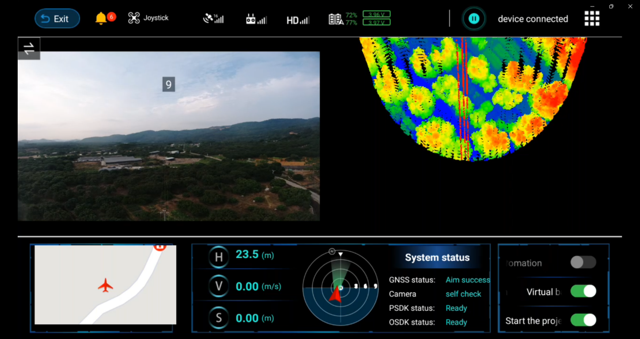
GreenValley App supports real-time 3D point cloud visualization, allowing users to view the integrity of the scanned terrain in real time while flying along the terrain. This feature allows users to instantly understand the status of field operations and is suitable for emergency investigations, disaster response and other time-sensitive scenarios.


图片3.png


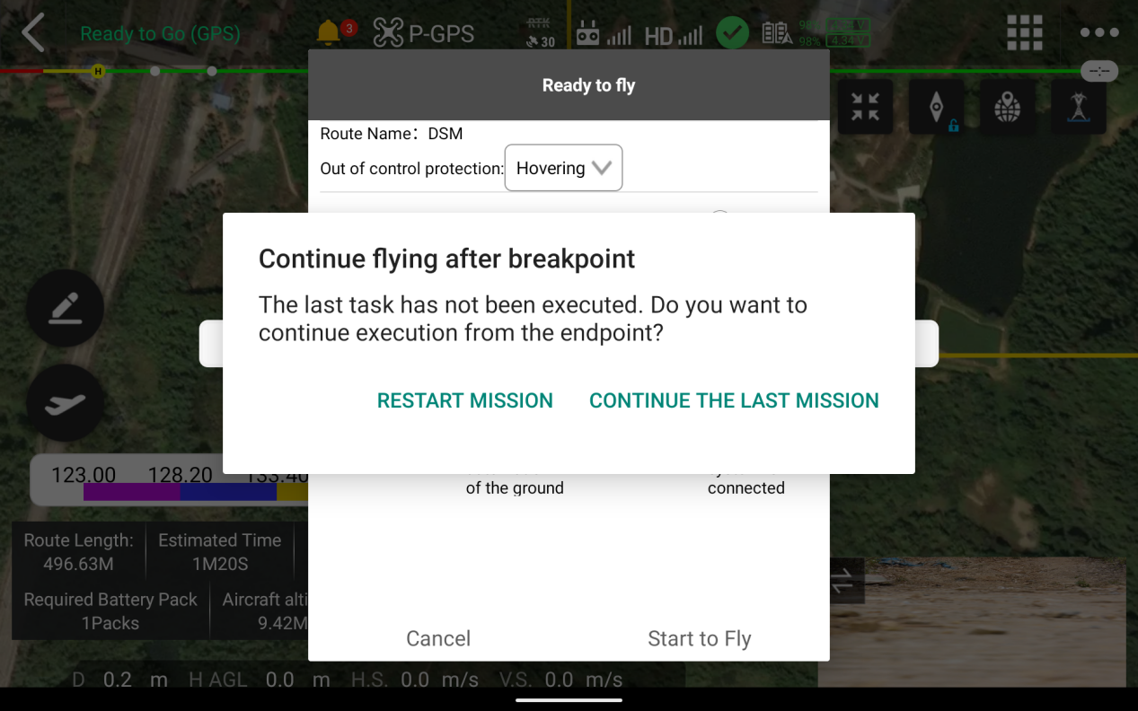
GreenValley App supports waypoint resumption, allowing users to resume terrain-following flights directly from the last completed waypoint in case the flight was interrupted due to insufficient battery or other reasons. This feature maximizes operational efficiency by minimizing downtime and optimizing the completion of survey missions.

图片4.png


In addition to the obstacle avoidance capabilities inherent in the aircraft itself, the equipment can utilize real-time point cloud data to assess the surrounding environment. If the equipment approaches an object on the ground within an unsafe distance, it will automatically hover and provide a warning. Multiple safety measures are implemented to ensure operational safety.


Function Testing


Terrain-following Success Rate of 95%


Error less than 10%

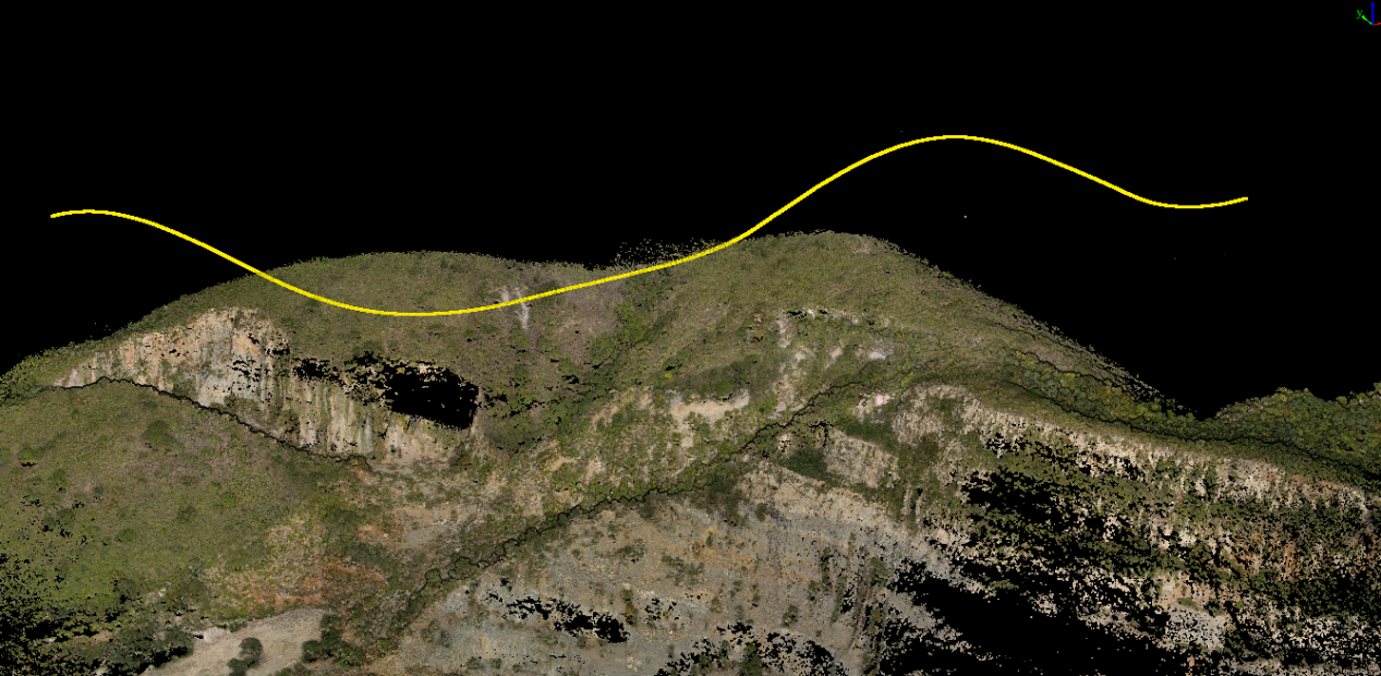
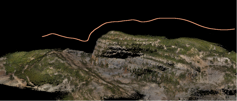
Currently, the terrain following function of LiAir X series products has been tested and used in various places. It has been applied in diverse scenarios including forests, mines, and more. The total number of flights exceeded 800, and the terrain following success rate reached an impressive 95%. During terrain following flight, the system maintains a constant altitude above the ground based on the input flight altitude, with an error rate of less than 10%.


图片5.png


image.png


image.png


Sample map information: In a coal mine and granite mine management area, the maximum height difference is about 100 meters.

Adjust the contrast of the sample image to make the colors appear brighter.
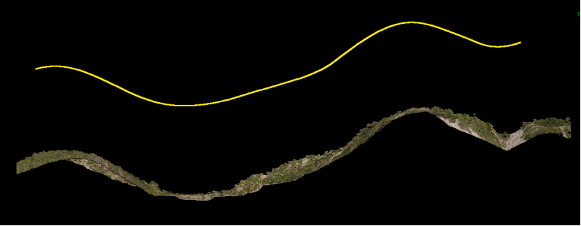

image.png

Aerial Surveying of Highly Undulating Terrain


How to Address Point Cloud Density Variations?

When conducting large-scale aerial survey operations outdoors, we often encounter terrain with large elevation changes. When performing fixed-altitude aerial surveys using lightweight short-range LiDAR systems mounted on unmanned aerial vehicles (UAVs), the effective measurement range is typically less than 300 meters. When the elevation difference is too large, insufficient measurement range will lead to sparse or even missing point cloud density in areas with relatively low elevations. Inconsistencies in overall point cloud resolution and density parameters can affect reconstruction results during data post-processing.

To address this issue, we can consider using a long-range LiDAR system. However, the high price of these systems often prevents many geospatial surveyors from adopting them.


Is there a more cost-effective solution? Yes! We can achieve it by utilizing the terrain-following function during aerial survey operations with UAVs equipped with short-range LiDAR systems. By consistently flying the UAV at a relative height above the ground that corresponds to the terrain variations, we can overcome this issue. This is the terrain-following functionality in aerial surveying.


Currently, there are two commonly used terrain-following methods on the market. The first method is to import digital surface model (DSM) files into flight planning software to generate variable altitude flight paths. DSM files can be downloaded for free from geospatial websites, but they tend to be lower resolution and less timely. Another approach is real-time terrain-following based on image data. However, this method is limited by lighting conditions and the drone lacks the ability to carry additional payloads, resulting in the inability to capture LiDAR point cloud data. Both methods have significant limitations. Is there a more convenient and efficient solution for terrain following?


GVI's Autonomous Terrain-following Function Enables Direct Terrain-following Flight without the Need for DSMs.


In response to the above problems, GreenValley International LiAir X series products incorporate a newly developed autonomous terrain following flight function specially developed for terrain surveying and mapping.


When used with the GreenValley APP and the DJI M300 drone, the system does not need to rely on DSM information specific to the measurement area. Instead, it leverages real-time processing of LiDAR point cloud data to generate local DSMs for terrain assessment. By considering the relative height of the drone to the ground, historical terrain data, and flight trajectory, the flight height is dynamically adjusted in real-time. This enables real-time terrain following flights without relying on pre-existing DSM data.


This feature greatly reduces data preparation time in advance and can be deployed and used immediately.


image.png


Process and Core Functionality Overview


GreenValley App supports both DSM-based terrain following and real-time terrain following modes. Users can choose the appropriate mode according to their specific needs.


图片2.png


When using the DSM-based terrain following mode, the GreenValley App supports two ways to obtain DSM data: local DSM import and online DSM download. The online download option allows users to automatically download the DSM file of the measured area via an internet connection. This eliminates the need for post-processing to generate DSM files or search resources online, saving time and greatly enhancing user-friendliness and operating experience.


image.png


GreenValley App supports real-time 3D point cloud visualization, allowing users to view the integrity of the scanned terrain in real time while flying along the terrain. This feature allows users to instantly understand the status of field operations and is suitable for emergency investigations, disaster response and other time-sensitive scenarios.


图片3.png


GreenValley App supports waypoint resumption, allowing users to resume terrain-following flights directly from the last completed waypoint in case the flight was interrupted due to insufficient battery or other reasons. This feature maximizes operational efficiency by minimizing downtime and optimizing the completion of survey missions.


图片4.png


In addition to the obstacle avoidance capabilities inherent in the aircraft itself, the equipment can utilize real-time point cloud data to assess the surrounding environment. If the equipment approaches an object on the ground within an unsafe distance, it will automatically hover and provide a warning. Multiple safety measures are implemented to ensure operational safety.


Function Testing


Terrain-following Success Rate of 95%


Error less than 10%

Currently, the terrain following function of LiAir X series products has been tested and used in various places. It has been applied in diverse scenarios including forests, mines, and more. The total number of flights exceeded 800, and the terrain following success rate reached an impressive 95%. During terrain following flight, the system maintains a constant altitude above the ground based on the input flight altitude, with an error rate of less than 10%.


图片5.png


image.png


image.png


Sample map information: In a coal mine and granite mine management area, the maximum height difference is about 100 meters.

Adjust the contrast of the sample image to make the colors appear brighter.


image.png

Recommended Articles

HOW CAN WE HELP YOU?
Message us your questions and contact information.
We’ll get back to you right away!